iPhoneユーザーのみなさん、おまたせしました。
iPhoneにGoogle Mapsと同様のアプリ、Apple Mapsがあることを覚えてますでしょうか。まさか普段から使われているとか・・・すぐにGoogle Mapsを使うことをおすすめします。
Apple Mapsは2012年に発表されたにもかかわらず、なかなか使えない地図のままここまで来たかと思います。
ですが、試しにApple Mapsを開き、
Brooklyn Bridge
と検索してみてください。2Dと3Dが切り替えられ、3Dにすると橋が立体的になり、右上のアイコンでドライブを選ぶとトラフィック情報も表示されます。
ブルックリン橋中央の吹き出しをタップし、Flyoverツアーを選べるようになってます。
iPhoneのマップでFlyoverツアーを利用する
iPhoneの「マップ」では、世界の主要な都市やランドマークの多くを上空から眺めることができます。
残念ながら日本はまだ2Dのみで、Flyover も未実装です。
2022年7月、15回目の地図拡張が行われフランス、モナコ、ニュージーランドが、14 番目、15 番目、16 番目の国になりました。
7,040 万人をカバーするこの拡張は、Apple にとってこれまでで 4 番目に大きな拡張でした。
4 年間の拡張と8 年間のデータ収集を経て、Apple の新しい地図データは現在、地球の陸地面積の 19.0% と世界人口の 9.4% (つまり、全世界で 7 億 4,300 万人)をカバーしました。
フランス、モナコ、ニュージーランドに拡大した後、Apple はベネルクス諸国 (ベルギー、オランダ、ルクセンブルグ)、スイス、リヒテンシュタインに次いで拡大する可能性が高いと思われます。
利用人口を考慮しながらヨーロッパで拡張を続けていますので、日本はまだ先になりそうです。
やっと使えそうなアプリになってきたApple Maps がこの10年でどうなったのか、ご紹介します。
オリジナルはこちらのブログです。要約して翻訳していますので、詳細はオリジナルをご覧ください。
Peters, Jay. “Apple Maps Turns 10 — and It’s Finally Worth Using – The Verge.” The Verge, 2 Sept. 2022, www.theverge.com/23323550/apple-maps-10-year-anniversary-iphone-google.
4ceo.jp では、無料の会員登録が可能です。過去の記事やメンバーしか読めない記事も順次増やしていきますので、ぜひご登録ください。無料です。
APPLE MAPSが10歳になり、ようやく使う価値がでてきました。(原題)
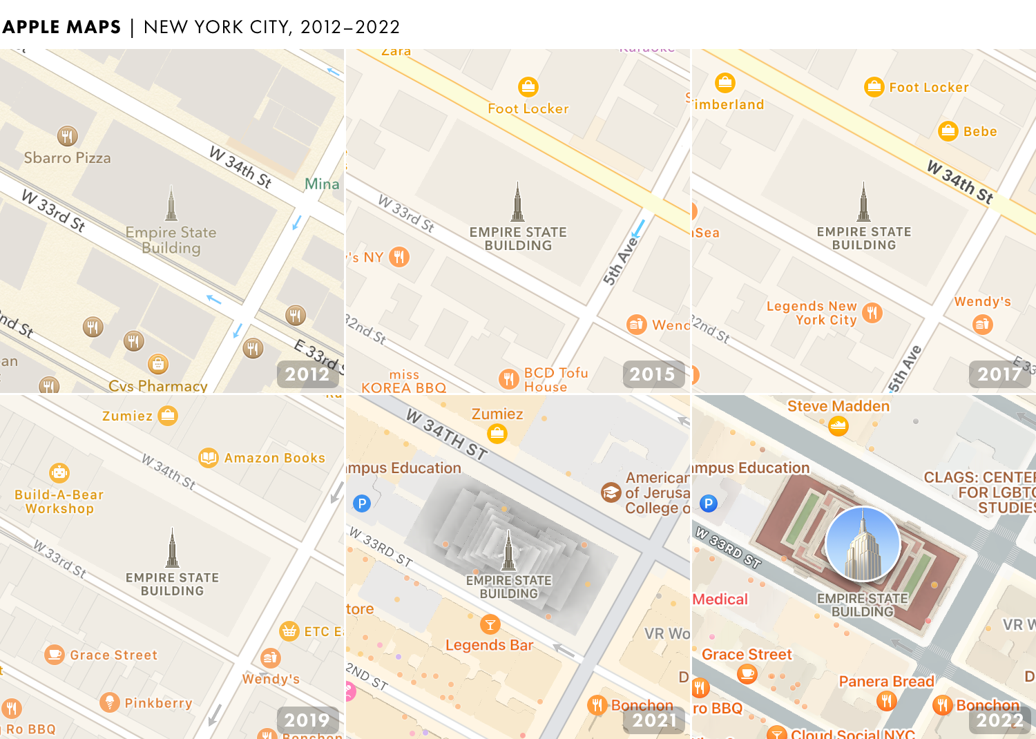
iPhoneをお持ちの方は、Apple Mapsでブルックリン橋をチェックしてみてください。
3Dで、イーストリバーにかかる橋が、マンハッタンのハイウェイとブルックリンの名を冠した公園の上にかかっている様子を見ることができます。
AppleのFlyoverツアーでは、天気の良い日に衛星写真から橋を撮影し、周囲のパビリオン、リバティ島の木々、イーストリバーを見ることができます。
確かに、橋はいくつかの角度から少しブロック状に見えるかもしれませんが、それは明らかにブルックリン橋です ー Apple Mapsが最初に起動し、橋が地面に溶けているように見えたときとは大違いです。
Apple Mapsの最初のバージョンであるブルックリン橋の写真です。写真The Verge
実際の橋はこんな感じです。Screenshot by Jay Peters / The Verge
溶けているブルックリン橋は、10年前にApple Mapsが導入されたときの数多くの奇妙な現象のうちの1つでした。
このアプリは、最近の記憶ではAppleの最悪の始まりの一つであったが、同社はそれを素晴らしい地図ソフトウェアとGoogle Mapsのライバルにするために十分な費用を費やしました。
今回の改訂は、この10年間で最大級のものです。
Apple Mapsは、Googleとの紛争から生まれました。iPhoneの初期には、AppleとGoogleは友人でした。
エリック・シュミットは、iPhoneが発売された当時、Appleの役員であり、Google MapsとYouTubeはすべてのiPhoneにプリインストールされていた数少ないアプリのうちの2つでした。
Google CEO Dr. Eric Schmidt Joins Apple’s Board of Directors
Google の CEO、Dr. Eric Schmidt が Apple の取締役会に参加
AppleとGoogleは、GoogleがiOSの代替となるAndroidを作ったことで敵対するようになりました。
特にマップはいたいところ突かれました。GoogleはiOSむけのマップから重要な機能をリリースしておらず、iPhoneユーザーにはターンバイターンの指示ができないままになっています。
The Real Reason why Apple Dropped Google Maps
AppleがGoogle Mapsを廃止した本当の理由
Appleは、Googleへの依存を解消するために、独自の地図アプリを開発することにしました。
当初、MAPSは絶対的な失敗作だった (iOS6)
2012年9月19日、AppleがGoogle Mapsに置き換わりました。さっそく大惨事となりました。
自由の女神はほとんど影になり、アイルランドでは公園を空港と誤表示しました。ゴールデンゲートブリッジの吊り橋の塔の上まで道路が登ってしまいました。
自由の女神はほとんど影に
アイルランドでは公園を空港と誤表示
ゴールデンゲートブリッジの吊り橋の塔の上まで道路が登った
Apple MapsはiOS 6の目玉でしたが、まだ完成していませんでした。
Appleは最も明白な間違いをすぐに修正しました。Apple Mapsがデビューした11日後、CEOのティム・クック(就任して1年)は、中途半端な発売を謝罪する公開書簡を書きました。
「アップルでは、お客様に最高の体験をお届けできるような世界クラスの製品を作るよう努力しています」とクックは書いています。
「先週、新しいマップを発表した際、この約束に背くことになりました。我々は、これが我々の顧客を引き起こしたフラストレーションのために非常に申し訳ありませんし、我々はマップをより良くするためにできる限りのことを行っています。」
iOSソフトウェアチーフのスコット・フォーストールは、この書簡への署名を拒否したため、1ヵ月後に解雇された。フォーストールが去った後、Appleはマップのトップマネージャーを解雇したと言われています。
iOS VP Scott Forstall and head of retail John Browett leaving Apple, Jony Ive taking interface design role
Apple has just announced a major executive shake-up: Senior VP of iOS software Scott Forstall is leaving Apple at the end of the year — he’ll be serving in an advisory role to CEO Tim Cook until…
iOS担当副社長Scott Forstallとリテール担当John BrowettがAppleを退職
Apple’s Scott Forstall’s fatal mistake was not signing iOS 6 Maps apology letter: sources
Scott Forstall — the departing Apple executive who’d become the public face of iOS in his role as head of mobile software — may have met his demise when he refused to put his name on the apology…
AppleのScott Forstall氏の致命的なミスは、iOS 6 Mapsの謝罪文にサインしなかったこと
Apple reportedly fires Maps manager after iOS 6 complaints
The flawed debut of the iOS 6 Maps application didn’t just leave some consumers frustrated — according to Bloomberg, it has resulted in one manager at Apple being fired outright. Richard Williamson…
Apple、iOS 6への苦情でMapsマネージャーを解雇と報道
Appleは、不安定なスタートを切ったマップの改善に着手。まず、ブルックリン橋と自由の女神が修正されました。
Appleは、アプリの基本的な機能と地図の精度を向上させるため、新興企業の買収を開始しました。1社はクラウドソーシングによる位置情報データ会社、2社目は乗り換え案内アプリを提供、さらに1社はGPSの新興企業です。
Apple acquires Locationary in effort to improve Maps
Apple has acquired Locationary, a crowdsourced location data company that helps businesses keep their information up to date. The company confirmed the acquisition to All Things D, noting that it…
Apple、マップの改善に向けLocationaryを買収
Apple purchases HopStop, will likely integrate transit directions into Maps
Apple is reportedly buying transit navigation app HopStop, according to a report from Bloomberg. A purchase would provide Apple with a solution for transit directions and navigation in its Maps app…
AppleがHopStopを買収、乗り換え案内をマップに統合する可能性が高い
Apple buys another popular public transit app to build out Maps
As part of a series of mapping startup purchases, Apple has acquired Embark, a popular public transit app that’s used in cities across the US. Former Wall Street Journal reporter Jessica Lessin…
Apple、Mapsの拡張のため、別の人気公共交通機関アプリを買収
アップルは主要な機能を削ぎ落としている
iOS 7では、サービスを強化するために、最もよく訪れる場所を共有するようユーザーに求めています。Apple Mapsの登場から3年後、iOS 9では公共交通機関の案内が追加されました。
iOS 10では、アプリの大幅な刷新によりナビゲーションが改善され、iOS 11では屋内地図が搭載されました。(この年、アプリのアイコンは宇宙船のキャンパスを描いたものに変更された)。
###iOS7
iOS 7 will ask users to ‘help improve Maps’ by sharing frequently visited locations
Apple has spent much of the last year working hard to improve its iOS Maps product, an app that was severely flawed when it launched with iOS 6 last September. The company picked up a few new…
iOS 7では、頻繁に訪れる場所を共有することで、ユーザーに「マップの改善への協力」を求める予定です。
###iOS9
iOS 9 brings public transit directions to Apple Maps
Update: Read the iOS 9 review.iOS 9 will give Apple Maps users the ability to receive public transit directions, restoring core functionality that Apple’s mobile operating system lost when the…
iOS 9では、Apple Mapsに公共交通機関の案内が追加されました。
###iOS10
Apple overhauls iOS Maps with a new design
Apple Maps is getting a redesign in iOS 10. Apple is calling it an “all new design,” but the real focus here is on the interface rather than the look of the maps. You’ll now see much more of the…
Apple、iOS Mapsを新デザインでオーバーホール
###iOS11
Apple adds indoor mapping and notification blocking to iOS 11
Apple is trying to stop distracted driving. The company announced today at its Worldwide Developers Conference that it’s launching “Do Not Disturb While Driving” as part of iOS 11. It’ll block…
Apple、iOS 11に屋内地図と通知ブロックを追加
Apple changed the Maps icon to show its new spaceship campus
Apple has been making all sorts of tiny changes to its app icons in the iOS 11 beta. And today, it made two of the most interesting changes yet: one to Maps, and one to the App Store.The Maps…
アップル、マップのアイコンを変更し、新しい宇宙船キャンパスを表示
しかし、ここまでしかできませんでした。
Apple Mapsはサードパーティのデータに依存していたため、Googleの足元にも及びませんでした。
Apple using TomTom and OpenStreetMap data in iOS 6 Maps app
We’ve been digging through the iOS 6 screenshots that were leaked to us earlier today for more details and found an interesting tidbit among them — TomTom is one of the main providers of mapping…
アップル、iOS 6の地図アプリにTomTomとOpenStreetMapのデータを採用
###iOS12
アップルは2018年のiOS 12で、マップの創業から6年後に、自社データによるマップの再構築を開始しました。
Apple is rebuilding Maps with its own data
Can Apple finally fix Apple Maps?
Appleは独自のデータでマップを再構築している
アップルは、カバーエリアのマッピングに多くの投資を行いました。ライダーアレイ、カメラ、iPadダッシュボードを搭載した地図作成用トラックを送り出す事業をすすめました。
「歩行者調査」は、徒歩でデータを収集します。センサーを入れたバックパックを持つ者もいました。
New Apple Maps Ground Surveys Begin in London, Birmingham and Manchester
Apple has launched ground surveys on the streets of London, Birmingham and Manchester to gather pedestrian data for its Apple Maps service using special backpacks to capture the necessary data.
ロンドン、バーミンガム、マンチェスターで新しいApple Mapsの地盤調査を開始
Apple Maps – Verzamelen van beeldmateriaal
Appleマップの画像収集作業について
Apple is rebuilding Maps from the ground up – TechCrunch
I’m not sure if you’re aware, but the launch of Apple Maps went poorly. After a rough first impression, an apology from the CEO, several years of patching holes with data partnerships and some glimmers of light with long-awaited transit directions and improvements in business, parking and place dat…
アップルはマップを一から作り直す
新しい地図は、カリフォルニアのベイエリアから順次公開されてましたが、かなり優れています。公園や森林を緑色で表示し、道路は幅を変えて表示することで、より分かりやすくなりました。
この改良された地図をモニターしたJustin O’Beirne氏は、いくつかの事例をブログで紹介しています。
アップルの新しい地図
Apple’s old maps (left) compared to the new (right).Image: TechCrunch
アップルの刷新されたマップが米国に触れるのは2020年1月です。(2019年末という予想より少し遅い)。
Apple delivers a new redesigned Maps for all users in the United States
The newly redesigned Apple Maps was built from the ground up to let users in the US more easily navigate and explore the world.
アップル、米国の全ユーザーを対象にデザインを一新した「マップ」を配信
###iOS13
AppleはMapsの外観を更新しただけではありません。最近のバージョンでは、新機能が追加されています。
アップルは2019年にリリースしたiOS 13で、「Look Around」というグーグル・ストリートビューのようなオプションを搭載しました。同じアップデートで、リアルタイムの交通機関の指示とETAの共有が導入されました。
Apple Maps is looking better than ever, but it still has a long way to go
The big Maps makeover that started in 2018 now includes all of the US Northeast.
Apple Mapsはかつてないほど良くなったが、まだ先は長い
###iOS14
iOS 14では、Google Mapsが以前から持っていたサイクリング指示と、Apple Carが実現した場合に有益かもしれないEVルートを追加しました。
Google Maps for Android gets better for cyclists with turn-by-turn bike navigation
Google Maps is getting some new features for cyclists as the company crosses the 500,000 kilometer milestone (actually 530,000; about 330,000 miles) for cycling routes (dedicated bike trails and…
Android版Googleマップ、ターンバイターン方式の自転車用ナビゲーションを搭載し、サイクリストの利便性を向上
Apple reportedly wants to launch a self-driving EV in 2025 with a custom chip
With no steering wheel
アップル、カスタムチップを搭載した自動運転EVを2025年に発売したいと報じられる
Apple adding cycling directions and EV routing to Maps in iOS 14
More long-awaited features that are already in Google Maps.
アップル、iOS 14でマップにサイクリング案内とEVルーティングを追加
###iOS15
iOS 15では、特定の町に3D情報を導入し、拡張現実の歩行指示、運転指示の強化が行われました。iOS 16では、マップにマルチストップルートが追加され、複数の駅を経由するルートを計画することができます。
iOS 15 and iPadOS 15 review: foundational fixes
Useful additions, but not flashy ones
IOS 15とIPADOS 15のレビュー:基礎的な修正点
How to use multi-stop routing in iOS 16 using Apple Maps
It’s easy to add stopovers in Apple Maps now.
Apple Maps を使用して iOS 16 でマルチストップ ルーティングを使用する方法
オレゴン州ポートランドでは、数年前からApple Mappingが私のお気に入りの地図プログラムになっています。iPhoneとMacBook Airを使えば、より良い体験ができますが、Apple Mapsは、ほぼ常に私が行くべき場所に連れて行ってくれます。
iPhoneのApple Maps、旧式の地図ではあるが。写真:Amelia Holowaty Krales / The Verge
「ほぼ、ほとんど」、まだそういうレベルなのです。
Apple MapsはGoogle Mapsと比較していくつかの利点がありますが、オフラインで使用するために地図をダウンロードすることができません。Appleがこれを提供するまでは、私は長旅の前にGoogle Mapsをダウンロードして、地図を保存しておくつもりです。
アメリカの大都市に住んでいる私も、Apple Mapsを使っています。ヨーロッパの同僚は、Appleが世界のサイクリングの中心地であるアムステルダムで自転車の指示をしないことに失望しています。
Amsterdam: cycling capital of the world
Become a real ‘Amsterdammer’ and travel by bike. You can rent a bike anywhere, but there are a few things you should know before you cycle through Amsterdam
アムステルダム:世界のサイクリングの中心地
Appleの刷新された地図は、2018年に発表されたにもかかわらず、イギリス、カナダ、オーストラリア、ニュージーランドでしかアクセスできません。
まだ拡張する余地があるとはいえ(アップル、レビューのYelp統合をなくしてくれ!)、アップルはマップをジョークから多くの人が使えるものに変えてしまった。
マップが始まった頃にそう言われても、私は信じなかったかもしれない。
XKCDによると、Apple Mapsはついに素晴らしいものになったそうです。
https://xkcd.com/2617/
ある日、周りを見渡すと、宇宙の不変の定数と思い込んでいたものが、変わっていることに気づきます。
現実の基盤が足元から揺らいでいるのです。
私たちは砂の上に建てられた家に住んでいます。
私がアップルマップが今、ちょっといい感じだと発見した日。